
Geographical Location of Sambalpur
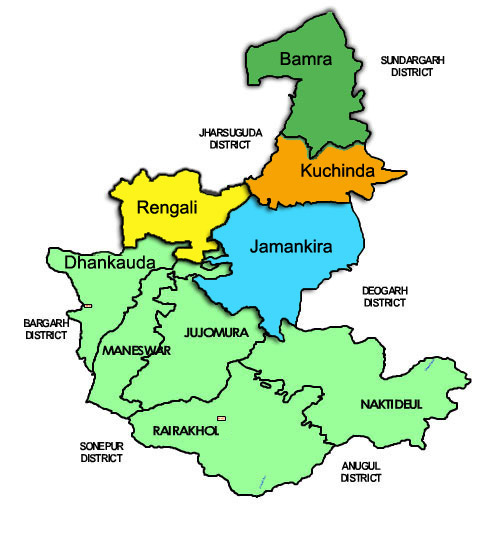
Sambalpur district lies between 20° 40′ N and 22° 11′ N latitude, 82° 39′ E and 85° 15′ E longitude with a total area of 6,702 square kilometres. The district is surrounded by many other districts like Deogarh district in the East, Bargarh (ବରଗଡ) and Jharsuguda districts in the West, Sundergarh district in the North and Subarnapur and Angul districts in the South. Sambalpur is the district headquarters of Sambalpur District. The district has three distinctive Physiographic units such as Hilly Terrain of Bamra and Kuchinda in the North. Plateau and Ridges of Rairakhol in the South-East and Valley and Plains of Sambalpur Sub-Division in the South-East. Sambalpur district experiences extreme types of climate with 66 rainy days and 153 centimetres of rainfall on an average per annum. The rainy season in this region started from June to October, and it was due to the South-West Monsoon. Here the temperature rises to 47° Celsius during May with the intolerable heatwave and falls as low as 11.8° Celsius during December with extreme cold. The rainfall is highly uneven and irregular.
The district forms a part of the Mahanadi(ମହାନଦୀ) River Basin. The Mahanadi is the longest river in the state and entered into the district in the North-Western border, where the famous Hirakud (ହିରାକୁଦ୍) Multipurpose Dam Project is built. Other important rivers of the district are the Maltijor, the Harrad, the Kulsara, the Bheden, and the Phuljharan. The district has a total forest area of 3986.27 square kilometres, which is around 59.46% of the total area of the district. The total land under cultivation in the district is 1,73,540 hectares. Most of the villages of the district are inaccessible during the rainy season. The presence of many streams without bridges cuts off the villages from the nearby roads. The district is benefited by National Highway No. 6, National Highway No. 42, Major district roads and a section of the South-Eastern Railway. Rural electrification has been extended to around 63.6% of the villages of the district. Telecommunication Network is not enough to fulfil the needs of the rural people. Drinking water facilities are available in villages mostly from the sources of tube wells.